Why does Quantified Conservation matter?
March 9, 2016
We believe if it’s worth doing, it’s worth measuring. When we take a meticulous approach to restoration, the result is a more comprehensive and accurate assessment of the benefits of those actions.
So we’ve built all of our projects around a Quantified Conservation approach. Quantified Conservation is about ensuring every restoration action taken translates to a positive outcome for the environment. It’s about methodically tracking the ways in which our restoration actions will improve water quality and quantity.
By quantifying the benefits of our projects, we can measure baseline ecosystem conditions, model the water quality benefit associated with the restored conditions, and monitor environmental gain over time. This approach will allow us to better target investments in nature and fix more rivers faster.
Modeling, measuring, and monitoring
To quantify environmental benefits, we rely on modeling and measurement. Models are a representation of a system using mathematical simulations of biological, chemical and physical mechanisms. These simulations utilize the best available science and understanding of natural systems. When we incorporate project site information, models allow us to predict conditions at a site that often cannot be directly measured. For example, using a soil erosion model, we can predict the loss of sediment from an agricultural field throughout the entire year, something that can be challenging to measure directly.
When modeling conditions at a project site, site-level information is essential. Field staff collect valuable information, such as habitat characteristics, vegetation type and distribution, land management practices and instream flow. These factors are measured in the field and then used to select the most appropriate model parameters to better represent conditions at the project site.
Incorporating field data into a model gives us a better understanding of site conditions. Additionally, the model representation of the project site allows us to test different restoration scenarios before implementation. We can simulate future site conditions, allowing us the opportunity to refine project designs and prioritize projects to get the greatest environmental benefits from the limited pool of restoration funding.
The Quantified Conservation approach does not end with project implementation. Long-term monitoring allows us to track the progress of a restoration site. Are the trees growing as expected? Is the water temperature changing as projected? The monitoring data we collect is used to measure outcomes, refine models, and test the efficacy of different restoration techniques.
How is it applied?
Let’s look at an example of how Quantified Conservation can be used to address runoff from agricultural fields.
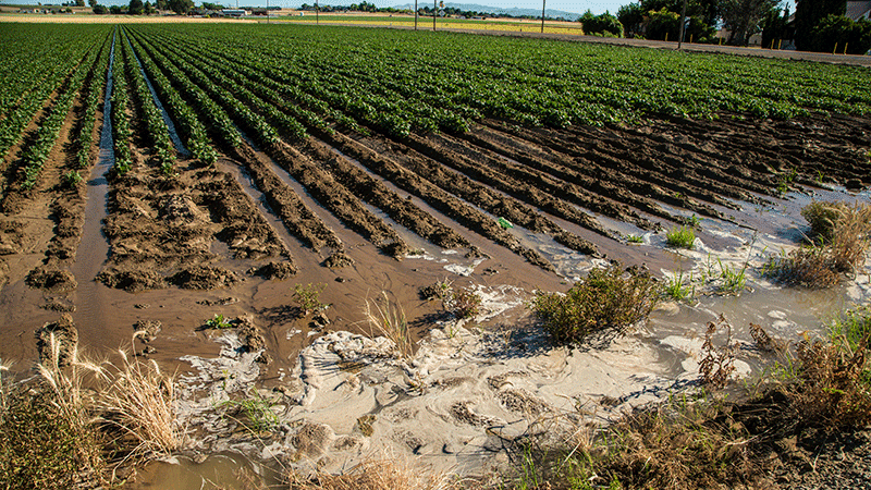
We know some fertilizers, pesticides and herbicides applied to agricultural fields to increase crop production do not stay where they’re put. A portion of these nutrients washes into streams and rivers and leaches into groundwater. This can result in nutrient enrichment, or eutrophication, which leads to excessive algae and plant growth, and degrades water quality. When plants and algae die, they sink to the bottom of a waterbody and decompose. The decomposition process consumes the oxygen in the water faster than it can be replenished. Over time, waterways with high rates of plant and algae growth are likely to become oxygen starved, or hypoxic. Waters without oxygen can result in fish kills and be harmful to human and animal health. For example, as a result of excess nutrients from the Mississippi River and its tributaries, the Gulf of Mexico now has a dead zone spanning more than 5,000 square miles.
“Quantified Conservation is about ensuring every restoration action taken translates to a positive outcome for the environment.”
Many conservation actions can address nutrient loading, including implementing agricultural best management practices, such as cover cropping, changing tillage practices, installing buffer strips, and restoring streamside buffers along fields. The implementation of these actions does not need to be a “best guess” exercise.
With the Quantified Conservation approach, we use specific models, such as the Nutrient Tracking Tool, to calculate the range of environmental benefits associated with changes in agricultural practices. As part of a watershed analysis, each agricultural field and land management action can be modeled. Analysis of all fields in a watershed employing a variety of land management actions allows us to identify the fields that have the greatest risk of soil erosion and nutrient loss. Through modeling, we can calculate how much nitrogen or phosphorus could be reduced through restoration or a best management practice. By evaluating the watershed with a consistent set of tools, we can develop a prioritized plan for reducing the pounds of phosphorus and nitrogen leaving specific fields.
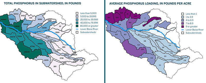
Caption (above): Analysis of phosphorus loading by subwatershed from surface irrigated fields in an Idaho basin. Conservation or land management actions to reduce phosphorus loading may include cover crops, no-till, and filter strips, as well as irrigation upgrades from flood irrigation to sprinkler or drip irrigation. Each action is modeled to estimate the quantifiable reduction in pounds of phosphorus that can be achieved.
Nutrients are not the only parameters we focus on for quantification. In addition to quantifying reductions in excess nitrogen and phosphorus, we also quantify reductions in excess sediment, thermal loading and water temperature, as well as beneficial increases in streamflow and stream habitat function. Since 2012, we have tracked these key parameters for the restoration projects we have designed and implemented.
How does quantification evolve?
We are building a new framework for doing restoration, and we recognize that not all the pieces will fit perfectly at the beginning. The results we are sharing in this report are modeled estimates based on our current understanding of the science and best available models at this time — not exact measurements. In the future, the models we use may change. Our understanding of the science may also broaden such that our results may need to be updated. The Quantified Conservation approach is a work in progress, yet the “act now and refine as we go” way has its advantages. It allows us to test our models and actions, giving us the data we need to refine them. The only way to create a strong and lasting system is to be open to new information and methods. This is also how we increase the pace and scale of restoration and be assured it is having the greatest benefit possible for a watershed. The ultimate goal is to develop a holistic understanding of freshwater environments and the benefits of restoration actions.
Where are we headed?
By using the Quantified Conservation approach, we are aiming to systematically improve the health of our freshwater resources. Restoration professionals, natural resources agencies, grant makers, regulators, regulated entities, environmental scientists and other stakeholders can rally around the field-tested models and the quantifiable units for tracking environmental benefits.
Small individual actions on a landscape can add up to big problems for our waterways. Each irrigator may take a small amount of water from the stream, but when these actions are combined, that diverted water can eventually mean a dry creek. Each farmer applies a small amount of nitrogen to a field of crops, but when combined, too much nitrogen can run into the rivers and choke out aquatic life and impair a drinking water supply.
But we also know the actions of individuals can add up to a big solution. When many farmers in a region improve irrigation and land management practices, excess nutrients and sediment entering a waterway can be reduced. When many landowners plant trees along a river for shade, the thermal load on the river can be reduced.
The whole of these carefully measured restoration actions is greater than the sum of its parts. Our Uplift Report helps us track this growing sum as we achieve real gains for the environment.
What has been the environmental response so far?
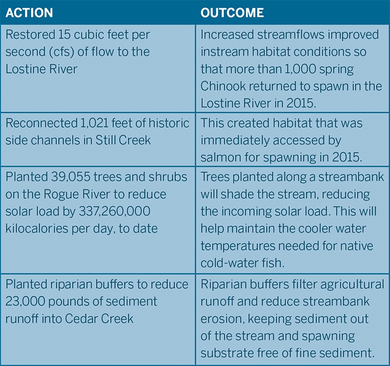
Prioritized restorations actions in key reaches of a watershed are not only captured numerically but demonstrated through positive responses from the environment. Here are a few examples from our projects:
Interested in learning more about our uplift results?
#freshwater health #habitat monitoring #measuring #modeling #nature #positive results #quantified conservation #research #Restoration #watershed restoration