Tools & Technology 
Environmental uplift can provide a robust picture of the project’s true ecological value.
Research, innovation and technology are the driving forces behind ensuring the actions we take deliver quantifiable positive outcomes for a river. We analyze data, model outcomes, and develop rigorous systems and protocols to quantify the environmental benefits of every restoration action.
We call these benefits “uplift.” Uplift is calculated by measuring the conditions of an ecosystem prior to a restoration project and then modeling the conditions that will result after a project has been implemented.
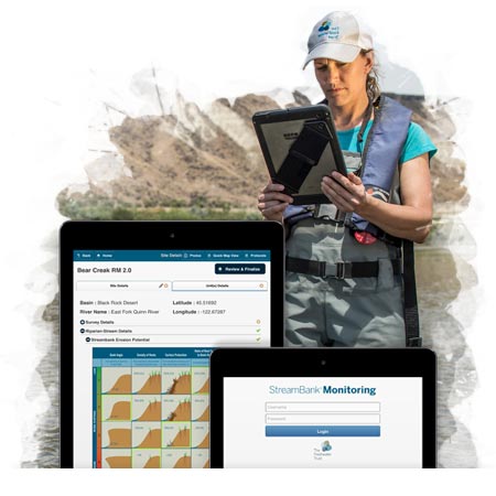
Calculating the environmental uplift for a potential restoration site can provide a robust picture of the project’s true ecological value, and help to prioritize implementation across a watershed. After the project is implemented, we use technology like our StreamBank Monitoring App to conduct long-term project monitoring to ensure that the project site is on-track to achieve the modeled benefits.
Ways we model ecological outcomes
We use publicly available, peer-reviewed models to quantify the benefits of conservation actions.
StreamBank® Toolkit
The Freshwater Trust has developed StreamBank® — a suite of tools we use for assessing watersheds, prioritizing restoration actions and monitoring benefits over time.
StreamBank includes:
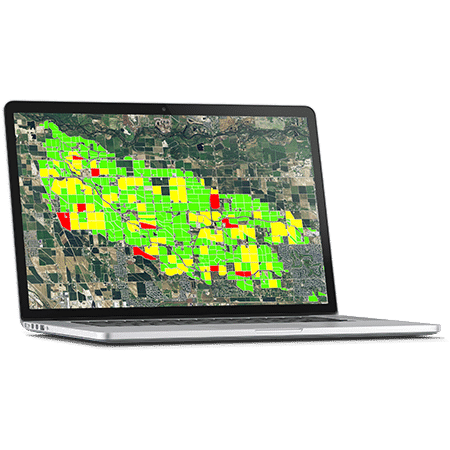
- BasinScout®, watershed-level diagnostics that allow for remote surveying of large landscapes and watersheds to estimate environmental uplift and prioritize restoration sites. Data outputs from BasinScout can create multiple conservation scenarios and identify the most efficient combination of projects, based on ecological and economic criteria, for achieving watershed-level goals. We’ve used BasinScout with program partners to assess opportunities to reduce the inputs of temperature, phosphorus, nitrogen and sediment to rivers, and also to prioritize surface water and groundwater augmentation actions.
- StreamBank Monitoring App, a tablet-optimized application for collecting monitoring data in the field, and compiling that data for long-term analysis and reporting.
- StreamBank Administrative Toolkit, a program management tool that allows for efficient implementation and tracking of large-scale watershed programs. Provides streamlined coordination among teams and project quality assurance.
The Freshwater Trust offers a variety of analytic services with this toolkit and uses it extensively with current program partners. Learn more.
Geographic Information Systems
A Geographic Information System, or GIS, is a tool that manages, analyzes and models data from our environment so that we can make smarter decisions to better conserve resources and protect biodiversity. GIS is used to answer a wide range of questions regarding spatial relationships at our project sites – from planning and design to implementation, data analysis, cartography and reporting.
Our staff routinely employs GIS to perform accurate earth measurements, conduct spatial analysis involving geometric properties and perform remote “field” sampling. GIS software also affords us capacity for complex analysis using LiDAR (Light Detection and Ranging) and satellite data and to perform change detection, site selection modeling and hydrologic modeling.
How do we know our innovations are moving the needle forward?
- Our efforts to develop standards for improved data collection and analysis methods are leading to new approaches in quantification science and advancing the field of restoration.
- Our StreamBank toolkit has received a U.S. Patent.
- More than $3 million has been awarded to fund our conservation tools.
- We’ve partnered with more than 15 municipalities and regulated entities to develop and implement watershed-scale conservation programs.
FAQ
The Freshwater Trust uses its StreamBank methodologies and outputs to provide analytic services to partners to help them build watershed restoration programs. We continue to seek funding and refine the methodologies for our work, including ways to make watershed analysis faster and more efficient. We work closely with organizations to configure the tools for specific geographies and train users to use the tools at their project sites. Please contact us if you are interested in using the StreamBank tools for compliance or conservation projects.
Shade-a-lator, a module of the HeatSource model for shade, calculates the pre-project load of solar radiation reaching the surface of a stream, creek or river, using pre-project conditions, including the current vegetation height and distribution. With inputs on mature vegetation height and distribution from planting and project designs, Shade-a-lator then predicts the future load of solar radiation reaching the waterway. The difference between pre-project and post-project solar loading represents the uplift and is reported in kilocalories per day.
When analyzing an agricultural area to determine current management practices and agricultural attributes at the field level, we use satellite information from a number of government and private organizations. These earth-observation data are paired with historical data for validation.
When translating those current conditions into conservation actions, we use multiple temperature, nutrient, flow and stream function models. These models pull from a variety of datasets, including publicly available data, such as soil characteristics, climate, topography and land use, as well as geospatial data from LiDAR, elevation models and satellites.
The Nutrient Tracking Tool (NTT) is a modeling tool supported by the USDA that quantifies the edge-of-field reduction in phosphorus, nitrogen and sediment from a conservation action. The NTT model considers on-farm drainage patterns, project designs and farm management practices to determine nitrogen, phosphorus and sediment uplift related to actions such as riparian restoration or livestock exclusion fencing. For example, The Freshwater Trust combined information from a landowner about current agricultural practices at the site (number of cattle, fertilizer application rates and irrigation practices) with multiple other datasets including soils, local weather and remote sensing elevation data – and then used NTT to model the nutrient runoff reductions possible by comparing the pre-project conditions to modeled conditions after the implementation of a livestock exclusion fence. The difference represents the project’s uplift in nitrogen, phosphorus and sediment, and is reported in pounds or tons per year.
We currently use the Stream Function Assessment Methodology (SFAM), a rapid assessment tool that evaluates stream functions and values. The methodology considers stream and streamside characteristics along with the ecological and societal benefits of that stream. This Excel-based calculator generates scores for hydrologic, geomorphic, biologic and water quality functions, as well as the importance of each of those functions. Both office and field data are collected pre- and post-project. Stream attributes, such as linear feet of side channel habitat, number of large wood pieces in a project reach, and the frequency and size of pools, are entered into the calculator to generate a score. The score represents a level of stream function, which is then used to quantify the ecological outcomes of restoration projects. Uplift at the project sites are reported using the unit of functional linear feet.
The Water Temperature Transaction Tool (W3T) estimates the cumulative impact of all restoration actions, including streamside trees and stream flow restoration, on water temperature. W3T uses river and landscape characteristics to estimate hourly incoming solar radiation and overall heat loss or gain from the stream. W3T also incorporates temperature and flow inputs provided by tributaries and meteorological and riparian vegetation information. Based on these inputs, W3T calculates the change in water temperature of a river reach as a result of a change in stream flow.
The Instream Flow Crediting Protocol is a new framework for a flow credit accounting process, which supports cooperative, transactional approaches to increase the amount of water in streams where volumes have been reduced by agricultural, industrial or municipal water withdrawals. A ‘flow credit’ is a discrete unit of water at a specific place and specific time, and is calculated as the product of magnitude (CFS), timing (days) and distance. Flow credits are summed to achieve an instream flow goal for a specified reach for a specified period. Additionally, flow credits can stand alone as water quantity credits or be translated into different units, including temperature or nutrient reductions or habitat created.
The StreamBank Monitoring iPad application records a variety of field measurements particularly geared toward tracking the long-term process of our restoration projects. There are nine features in the app, including vegetation monitoring, riparian function assessment, shade measurements, photo point monitoring, redds (spawning) surveys and substrate monitoring (pebble counts). These data help to assess and quantify the level of function in streamside vegetation, and help us make recommendations for conserving high-quality areas or restoring degraded areas.
We are currently developing versions of the BasinScout methodology to analyze both groundwater and stormwater. Our prototype BasinScout for groundwater quantity uses data from the Salinas and Sacramento-San Joaquin Valleys.
The tool combines multiple sources of information about a water resource—economic, environmental and social—for rapid modeling of multiple water allocation scenarios in order to understand the trade-offs associated with various groundwater usages and extractions. A prototype of BasinScout for stormwater characterizes urban land management best management practices (BMPs) to control stormwater runoff and prioritizes sites within the urban landscape where these actions could be implemented for maximum environmental benefit. The Freshwater Trust continues to develop these new types of assessments within the BasinScout methodology as we focus on the complex water problems in the West.
The key benefit of BasinScout is the specificity of its recommended actions. Building a watershed-scale or basin-wide restoration program with BasinScout allows you to target the particular fields that can generate the greatest environmental benefit. In a region with hundreds of thousands of acres, you can hone in on the few dozen fields where conservation actions have the most impact.
BasinScout uses field-specific costs and outcomes of best management practice (BMP) implementation scenarios to prioritize sites based on user-specified criteria. For example, the user can specify that they want to prioritize recruitment based on the reduction in groundwater demand achieved per dollar spent on irrigation upgrades, and BasinScout will provide a list of sites where irrigation upgrades are feasible, ranked in order of cost-efficiency for achieving groundwater demand reductions.
Get in touch
Have questions about our research and technology?
David Primozich, Vice President - Water
Contact Me At
Portland (Main Office), OR
503-222-9091
ext. 19
Email David