Capturing a California river
August 1, 2016
The Freshwater Trust recently released its 2015 annual report, where we highlighted big accomplishments from the past year. Each week we will feature a new staff article from this report in the hopes that you will celebrate these milestones with us. Stay tuned for more.
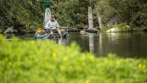
15 photos every 2.5 seconds. That’s how you capture a California river. At least that’s how The Freshwater Trust did it when we took Google’s Trekker out on the Russian River. Through this intensive river float, we collected imagery to identify and prioritize the restoration needs for this watershed that so many people and wildlife rely on for survival.
Check out the full story below.
In 2015, The Freshwater Trust took the Trekker, Google’s 15-lens camera, strapped it to an in atable raft, and oated it down the length of California’s Russian River. A small flotilla of scientists took turns at the helm of the craft, the orb sitting tall on a pedestal and doing its job to snap 15 photos every 2.5 seconds.
While it doesn’t take much convincing for any of our staff to put palm to paddle, this trip wasn’t just for adventure. For more than 60 miles, the camera collected imagery of streamside vegetation and river conditions to be used for identifying and prioritizing restoration sites.
Snaking southward and draining Sonoma and Mendocino counties, the Russian River provides drinking water for several hundred thousand Californians and serves as critical wildlife habitat for fish migration and spawning. The watershed has also been used to support vineyards and valuable orchard crops. Yet loss of streamside vegetation, overbearing invasive plants, and excess sediment from runoff have impacted the region’s waterways. The majority of the streams in the basin are listed as impaired under the Clean Water Act.
Using images gathered from the trek, The Freshwater Trust estimated that 30% of the Russian needs revegetation to lower the water temperatures to a more hospitable level for fish, filter nutrients and runoff, and stabilize the banks. More than 6,500 occurrences of invasive species were also mapped with the help of the imagery gathered from the trip.
“Our partnership with Google Maps gave us invaluable insight into what parts of the river need the most work,” said Mike Jolliffe, applied research scientist with The Freshwater Trust. “We could clearly see the problems and understand the path forward to fixing them. It was a great example of 21st century conservation in action.”
Through your support we are able to keep working to secure a future with clean, healthy waterways for all.
#California #Clean Water Act #fix rivers #Google Trekker #habitat #nature #photography #Restoration #Russian River #science #scientists #vegetation #water temperature #wildlife