BasinScout: Surveying Entire Watersheds to Prioritize Conservation Actions
February 9, 2024
For more than a decade, BasinScout® has been one of the core technologies that underpins The Freshwater Trust’s analytical prowess. When we practice and promote “quantified conservation,” this is where it begins. We chatted with members of our Science & Analytics Team to get the scoop on BasinScout. Eleanor Bash, Geospatial Hydrologist, and Tommy Franzen, GIS Developer, describe how we manage and combine data to gain insight and what’s on the horizon for this incredibly powerful technology.
To begin, what is BasinScout®?
Eleanor: BasinScout is a set of software tools we use to handle a huge amount of data about the environment. Basically, it boils down to evaluating conservation opportunities across large geographic areas and highlighting the projects with the greatest benefits and lowest costs. We are always evolving the tools and the data they use, but the goal of BasinScout hasn’t changed since it started.
Tommy: One of our colleagues coined the name BasinScout back in 2012. At that time the term was used to describe the analytical workflow that would allow us to quickly “scout” the 15 to 20 most cost-effective riparian shade projects within the Rogue River Basin. As our analytics have evolved and our geographic scope has increased, the core components of evaluating large amounts of data and finding the most cost-effective projects with the best environmental impact have remained.
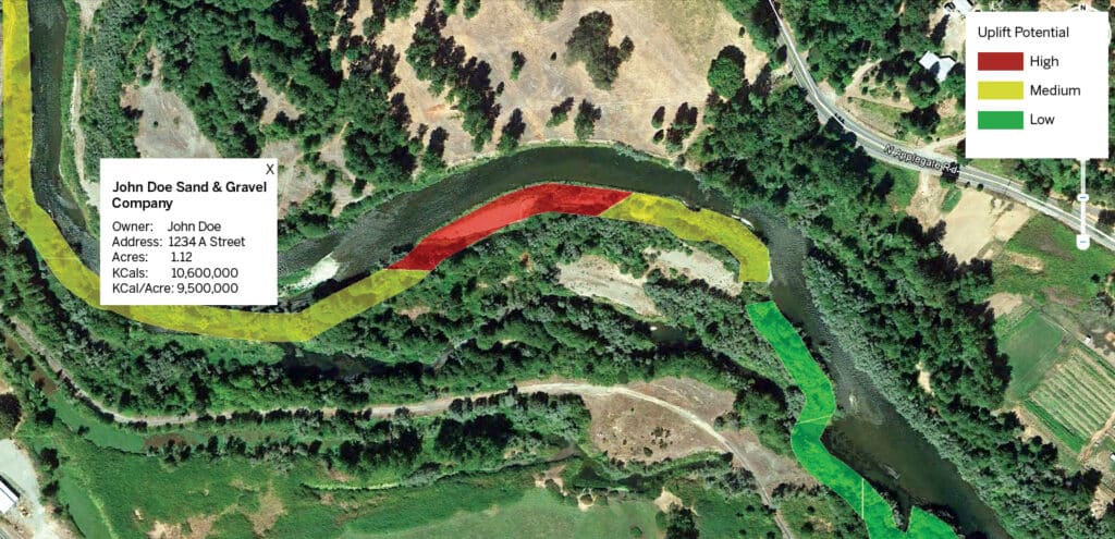
TFT’s earliest use of BasinScout helped address rising water temperatures. We determined a site’s potential for adding riparian (streamside) shade prior to committing significant resources to a restoration project. This analysis allowed us to prioritize our restoration efforts to achieve the most ecological gain on the ground.
What’s an example of a positive environmental outcome that started with BasinScout?
Eleanor: BasinScout has provided much of the insight that drives our water quality trading programs with utilities. For example, our riparian revegetation work on Oregon’s Rogue River has reduced solar load by almost 750 million kilocalories per day. This means that the thousands of trees strategically planted along the river’s edge are casting shade that protects the habitat of cold-water species such as salmon. Another good example is our work in the Snake River in Idaho and Oregon. We are using BasinScout to guide conservation investments in this area toward projects that will have a big impact on water quality in the river through phosphorus runoff reductions.
Where does BasinScout fit into The Freshwater Trust’s analytical toolbox?
We use different models in BasinScout. What are they and how are they incorporated into the process?
Eleanor: Yes, we use several recognized, vetted models. These include Shade-a-lator for solar load and Nutrient Tracking Tool (NTT) for calculating ways to reduce nitrogen and phosphorus runoff. The value-add from BasinScout in using these models is in the efficient piping of data into and out of these models. For example, in the case of NTT, we’ve taken a field-scale model that requires dozens of data inputs, and we’ve built functionality into BasinScout to automatically extract much of this data from satellite imagery and other remote sensing data for hundreds or thousands of agricultural fields at a time. That’s a huge time savings. It’s all about increasing the scale and speed of the analysis.
Tommy: Starting with the Shade-a-lator model, developed by the Oregon Department of Environmental Quality, we created a really effective analytical workflow. It aggregates the highest potential shade results per specific location (in this case, the units are tax lots) along with rough cost estimates. This lets our project managers know where and who to target their outreach for riparian revegetation sites. Basically, what are the best spots along the river that could cast the most shade for the least cost? With this streamlined workflow, we have built prioritized implementation plans for our water quality trading clients that met their budgets and created environmental benefits for the whole watershed.
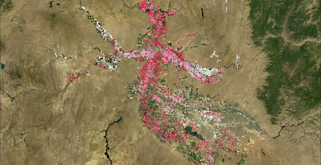
BasinScout analysis of 20,000 agricultural fields in an Idaho river basin with impaired water quality. The fields are ranked by attenuated phosphorus load reduction, where red represents high and white represents low phosphorus reduction. This analysis shows us that more than 1 million pounds of phosphorus can be removed through feasible, targeted irrigation system upgrades.
BasinScout also makes use of different geospatial tools. How do these tools help?
Tommy: Geospatial tools, and more broadly geospatial data, often form the backbone of our BasinScout analyses. Here comes the nitty gritty: We utilize desktop software such as ArcGIS and QGIS for developing map products and ArcGIS Online for developing interactive dashboards to display analytical results. (GIS stands for geographic information system.) We leverage Python, a high-level programming language, for creating scripts and proprietary GIS tools that are used to ingest data, perform a variety of spatial analyses, and store results in a geospatial-enabled database.
Eleanor: The world of geospatial analytics is constantly evolving, and we are trying to evolve with it. For example, we use Google Earth Engine to access and process data from five or six national datasets over thousands of fields and multiple years. Doing that on a desktop computer could take months, but now it takes just hours. Tools like Google Earth Engine and a variety of products within Google Cloud Platform have helped us improve the way we access, process, and store geospatial data—such as crop data, weather data, and elevation models—for use in BasinScout.
How have BasinScout and those who use it evolved?
Tommy: BasinScout has evolved from the initial riparian shade-based application to addressing a wide range of water quality and water quantity issues across the Western United States. We have developed workflows and products for clients that can prioritize groundwater aquifer recharge, agricultural irrigation upgrades, strategic fallowing (crops and pasture), and mitigation actions for pollutants such as mercury.
Eleanor: As the tools have become more complex, the skills needed on our analytical team have changed, too. It used to be GIS experts handling the data and subject matter experts providing scientific guidance. Now the two roles have blended into this hybrid data scientist role, where we have subject matter experts who are equipped with skills in GIS, statistics, and computer programming.
While the skills of our team are evolving, the importance of people on our team with expertise in conservation remains constant. Software and technology are tools to help us answer questions, but it takes biologists, agronomists, hydrologists, and other trained staff who can understand the problem and articulate the questions we want to ask.
What changes do you see coming that will help us achieve conservation goals more quickly and effectively?
Eleanor: BasinScout will always be changing to address new questions and find new solutions, but I am most excited about some of the things that aren’t changing anymore. Those parts of BasinScout that don’t need to be changed and can still be applied in lots of geographies prove that we’ve developed something incredibly useful.
What is your favorite part of BasinScout?
Eleanor: It is really interesting to learn about the various ecosystems that we are trying to protect. For example, in California’s Sacramento and San Joaquin Rivers, BasinScout is guiding the implementation of groundwater recharge projects that will secure, protect, and enhance more than 4,000 acres of sensitive groundwater-dependent habitat for decades. This includes streamside oak forests and Sandhill Crane roosting and foraging habitats.
Tommy: My favorite part of BasinScout is the constant evolution and refinement. In six months or one year from now, BasinScout will likely have more improvements and capabilities, while still rooted in the same concepts that were developed more than ten years ago. We are also developing BasinScout to adapt to very large geographic areas. Currently we are using BasinScout to analyze water quality and water quantity issues across the entirety of the irrigated agricultural land in Southwest Idaho and the West Slope of Colorado, which combined encompasses nearly 1.5 million acres.
BasinScout® is a registered trademark of The Freshwater Trust. Aspects of the StreamBank® system, of which BasinScout is a part, are covered by one or more claims of U.S. Patent No. 8,036,909.
#agriculture #BasinScout #GIS #irrigation systems #phosphorus #quantified conservation #riparian restoration #river conservation #runoff #technology #uplift